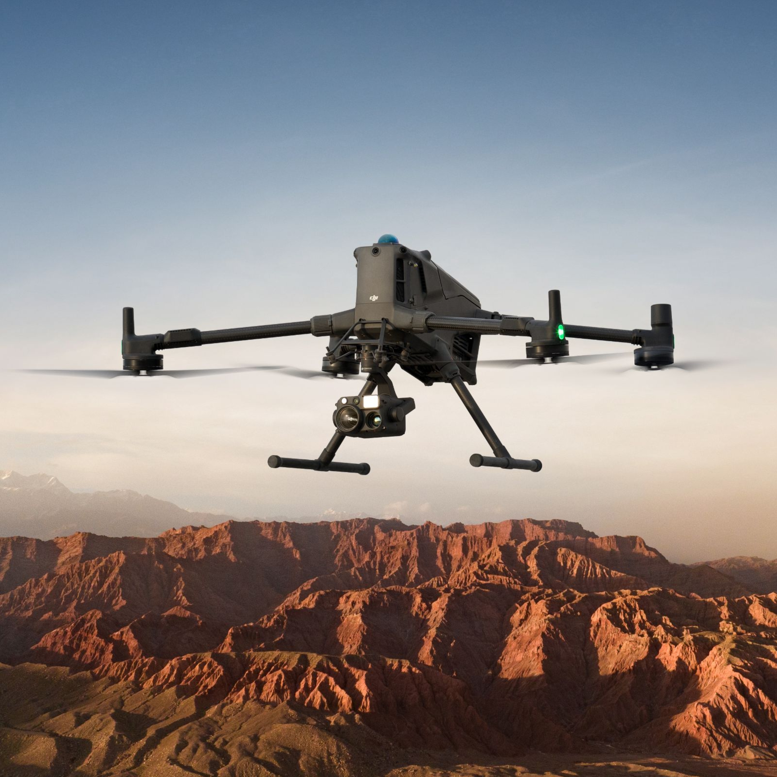
Introducing the DJI Matrice 400: A Leap Forward in Drone Technology
The DJI Matrice 400 is engineered to meet the demanding needs of enterprise operations. Key features include:
Extended Flight Time: Up to 59 minutes of flight duration, allowing for prolonged missions without the need for frequent battery changes.
Increased Payload Capacity: Supports up to 6 kg, accommodating a variety of sensors and equipment for diverse applications.
Advanced Obstacle Sensing: Equipped with rotating LiDAR and mmWave radar systems, providing comprehensive obstacle detection and avoidance capabilities.
Versatile Payload Configurations: Features multiple gimbal mounts and E-Port V2 connectors, enabling the integration of up to seven payloads simultaneously.
These enhancements position the M400 as a versatile platform capable of supporting complex and multifaceted missions.
🚀 Payload Capacity: Up to 6kg
The headline upgrade is the increased payload capacity—up from the M350’s ~2.7kg to a generous 6kg. This enables support for heavy-duty sensors, including high-precision LiDAR units like the RIEGL miniVUX, multispectral sensors, or advanced communication hardware.
🧠 Edge AI Capabilities
Built-in support for AI models at the edge means real-time processing of imagery and data—no need to wait for cloud uploads. Combined with DJI’s SDK ecosystem, this enables intelligent workflows like:
Real-time thermal object detection (humans, animals, vehicles)
Smart anomaly alerts for inspections
AI-assisted navigation in low-visibility environments
🔥 Thermal Object Detection Model
The M400 debuts DJI’s native thermal object detection model, allowing the drone to:
Automatically detect and classify hot spots
Highlight humans or animals in dense vegetation or at night
Pinpoint fire edges, escape routes, or missing persons during SAR
New Use Cases Enabled by the M400
The hardware and software improvements unlock new or improved workflows across industries:
🔍 Infrastructure Inspection
Carry heavier zoom + thermal combos for line inspections
Use AI to flag corrosion, hotspots, or insulation faults
🛰️ Surveying and LiDAR Mapping
Mount survey-grade LiDAR like the RIEGL miniVUX
Longer flight time with heavy sensors for corridor or topographic mapping
🛠️ Construction and Industrial
Deploy multi-payload setups (LiDAR + RGB + Spotlight) in a single flight
Feed AI models for site progress analytics
🌾 Agriculture and Environmental
Monitor wildlife or livestock with thermal object detection
Perform precision NDVI and multispectral surveys
Combine with weather or gas sensors for environmental monitoring
What Defines an Enterprise Drone?
Enterprise drones go beyond aerial photography. They’re designed with advanced sensors, extended flight times, modular payloads, and compatibility with fleet management systems. These capabilities make them reliable tools for critical missions, especially where precision and repeatability are key.
Key attributes of enterprise drones include:
High payload capacity (like the DJI M400’s 6kg rating)
Interchangeable payloads (e.g., LiDAR, thermal cameras, multispectral sensors)
RTK/GNSS positioning for centimetre-level accuracy
Enhanced redundancy systems for safer operation
Why Drones Still Matter in the Field
Despite the rise of automation and satellites, drones remain unmatched in their ability to collect real-time, high-resolution data at low altitudes. Here are several reasons why drones continue to be indispensable tools:
1. LiDAR Mapping & Geospatial Surveying
With the ability to carry compact, high-end LiDAR systems—such as the RIEGL miniVUX—enterprise drones like the M400 can rapidly generate 3D terrain models. This is critical for:
Construction planning
Vegetation encroachment monitoring
Mine site modeling
Corridor mapping for utilities and railways
In Australia, these services are vital for both urban infrastructure and remote site development, especially in regions where traditional surveying is logistically difficult or dangerous.
2. Thermal Object Detection
With thermal payloads and onboard AI, drones can now detect heat signatures of people, vehicles, livestock, and powerline faults. This is key for:
Asset inspections (solar farms, substations)
Emergency services (search and rescue, bushfire response)
Wildlife tracking or poaching deterrence
Livestock counting and health checks
The DJI M400’s new AI integration enables onboard thermal object detection, which means smarter data collection with fewer post-processing delays.
3. Water Sampling and Environmental Monitoring
In areas prone to runoff, contamination, or mining impact, drones equipped with remote water-sampling payloads can collect samples without risking human operators. Combined with multispectral sensors, these systems support:
Wetland and river health monitoring
Salinity and sedimentation studies
Compliance mapping for mining and agriculture
4. Infrastructure and Utilities Inspection
Enterprise drones help small businesses deliver high-value inspection services. From tower inspections to flare stack surveys, drones reduce costs, downtime, and risks. In Australia, where large-scale infrastructure often spans isolated terrain, having a platform like the M400 that can carry advanced zoom or thermal cameras is transformative.
Why Small Businesses Are Embracing Drones
In Australia’s competitive drone services market, small operators are increasingly turning to platforms like the M400 to offer:
High-resolution topographic mapping
Precise inspection reporting for clients in energy, transport, and mining
Real-time analytics using thermal, multispectral, and AI-powered payloads
Enterprise drones offer strong return on investment (ROI) through:
Faster data acquisition
Lower manpower requirements
Reduced operational risk
Competitive differentiation with premium data outputs
Ready to Fly Smarter?
The evolution of enterprise drones—culminating in platforms like the DJI M400—is unlocking smarter, more capable operations for businesses across Australia. Whether you’re mapping terrain, inspecting powerlines, detecting heat signatures, or sampling environmental data, drones remain a critical piece of the industrial technology puzzle.
If you're exploring DJI drone solutions for LiDAR mapping, thermal inspections, or AI-integrated workflows, reach out to discuss how to build your own smart drone fleet with the right hardware, payloads, and software support.
Ready to Put Drones to Work?
Discover how to implement these drone solutions in your business and unlock the full potential of your data. Let's discuss your specific needs.